Map: How I got from the UK to China by train

This slideshow requires JavaScript.

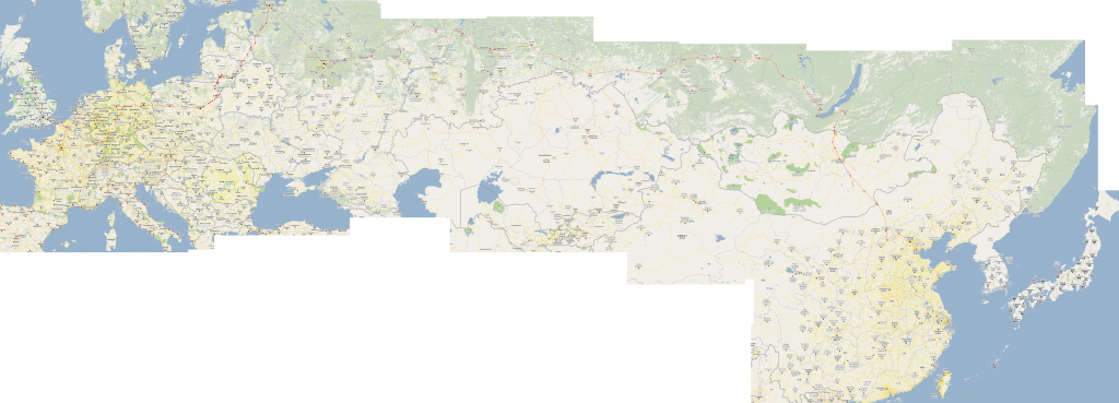
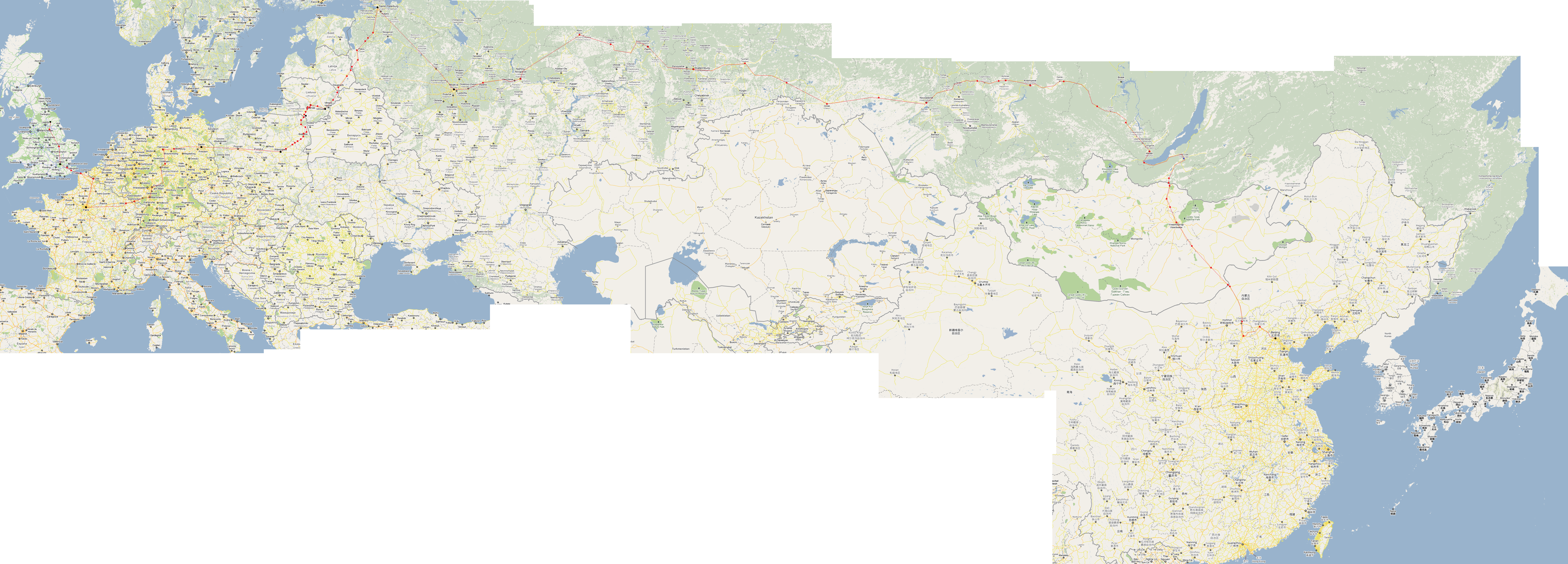
This is quite cool – just going through some old files and I found this map from my travels back in 2010. It’s a map of the route I took to get from York in the UK to Beijing near the Chinese coast – entirely by train.

The map is an enormous PNG file. I travelled with no technology (how much things have changed now!) and used an A4 folder to carry all of my information with me. The map is nothing more sophisticated than lots of screen grabs of Google Maps stitched together, then I drew the route on the resulting image in Paint. The red line shows the route. Red dots are stopping stations. Black dots are where I changed trains. The map may not look flashy, but it served its purpose, and it showed the route clearly when printed at 300dpi.

The entire journey took about three weeks including around 7 days of sight-seeing along the way. The bulk of the journey mileage was handled by the Trans-Mongolian train, which is a 6-night direct service between Moscow and Beijing. Travelling through Europe was done with a combination of day and night trains. The Man in Seat 61 provides an excellent introduction to the different ways to get to Moscow from the UK – I chose the slightly awkward route via St Petersburg to avoid needing an expensive Belarusian visa.

We normally think of the world as a very big place, where the only way to travel long distance is by air. There is something very humbling about going by train though, to think that there are two strips of carefully engineered steel running almost continuously half way around the world. To see every town along the way, see the timezones, climates, geography and flora changing along the way, really gives a sense of scale of the world that can’t be felt when travelling by plane.

Here is the map. To see the full-size version, it’s best to open it on your computer. Right-click here, and choose ‘save image as’. (Note it’s a 10MB image if you’re on a slow connection!)

Map of Europe to Asia train route

Convert a network of roads into 2D curve plans in Grasshopper

Building on from my Road Maker, where the centrelines of roads can be converted into 2D meshes suitable for rendering more realistic roads in Grasshopper (as done here), a recent task at the office required that these meshes then be turned into a collection of curves marking the outline of the road.

This Grasshopper script enables you to do this, using a couple of standard Grasshopper components. The basic workflow used here is to get a network of roads using Elk and OSM data.

elk-1

The Road Maker then converts this network into 2D meshes. We then extract the mesh edges and then use the RUnion to tidy it up as much as possible. The final result isn’t perfect but should minimise the amount of manual work needed at the end.

elk-2

We should then get a result that looks like:

road-network-curves-grasshopper

Planning a ski trip to Japan: A ski map of Hokkaido

As part of my research into my first ski trip in Japan, I have been researching the different places to go.

I am a relative beginner with little over a week of experience, but I’m wanting somewhere with the best snow, a good mix of slopes, and away from the crowds. In Hokkaido, we’re spoilt for choice and it can be quite bewildering to know where to go, where to stay and how to get around.

I put together the map of Hokkaido ski resorts below as an evolving work to help understand the different regions in Hokkaido for skiing. I haven’t actually been to any of the places below yet, but it is quite a useful tool for putting together my plans. I have also saved piste maps into each of the resorts – zoom in and click a ski icon to take a look.

Full screen version: click here.

It seems that many of the most exciting and promising resorts can be accessed within a couple of hours of Sapporo by train, even the distant Tomamu in the east. With a JR pass, it’s very easy to get about by train, and it will likely be cheaper to stay in Sapporo and do day trips to lots of different resorts. Furano is the only significant exception that’s a little too far – maybe a couple of days at a hotel there?

The PowderHounds website (and their own ski map) was an excellent resource in my map and my own planning. I recommend you take a look, especially at their list of top resorts.

Anything I’ve missed out? Any other amazing places you can recommend?

Rendering cities in Rhino with OpenStreetMap data

This slideshow requires JavaScript.

Using the freely available map data from OpenStreetMap (OSM), it is possible to create maps and renders of towns and cities within Rhino.

Most of the hard work was done by the creators of Elk, a plugin for Grasshopper that parses OSM data files and returns geometry sorted into roads, rivers, railway lines and so on. It’s then just a matter of taking that geometry and modifying it to suit your visual requirements.

And once the data’s in Grasshopper, we can do all the usual crazy Grasshoppery stuff to it. In the last image above, I connected the buildings up to a bit of C# to show its distance to a given point using colour. I think I like this version of Bath more…

2015/03/31 Update: How to do this yourself

Great news! After some digging around I have stumbled upon the Grasshopper definition I used to create this. If you want to do this for your own town, it is quite simple:

  1. Visit OpenStreetMap. Zoom into the area of interest, click ‘Export’ at the top, and then the blue ‘Export’ button on the left. The file size should be much less than 10MB for decent performance. If the file is too big then zoom in and try again.
  2. Download Elk – which provides the Grasshopper components to parse the OSM file
  3. Download my Grasshopper definition and open it in Grasshopper. At the very left, import the OSM file.

This definition was made many months ago when my knowledge of meshes (and how to make them faster) was much less. I’ve since become more proficient in making really lightweight meshes. I think that Grasshopper can handle much larger maps than this current definition will allow, and one day I plan to see how far I can take it. But this will have to do for now 🙂

2015/07/11 Update 2

As promised, I have had another go at this, and I have now modelled the entire centre of my city York. Take a look and download the GH file here.